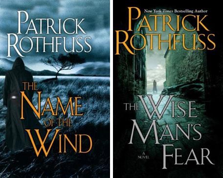
Welcome to the first of the speculative summation posts I’m going to be doing in between volumes of my ridiculously detailed re-read of Patrick Rothfuss’s Kingkiller Chronicles. Last week’s post finished The Name of the Wind, and after we’ve summed up some of the speculation we’ll be moving on to The Wise Man’s Fear — but these discussions assume you’ve read all of both books. These posts are full of spoilers please don’t venture beyond the cut unless you want them.
Abbreviations: NW = The Name of the Wind. WMF = The Wise Man’s Fear. DT = Day Three, the forthcoming final volume. K = Kvothe or Kote when I can’t figure out what to call him and I’m feeling Kafkaesque. MT: Myr Tariniel. D = Denna
Useful links: The Sleeping Under the Wagon post, in which there are lots of theories. The re-read index. The map.
We will have three more speculative summary posts after this one, on Denna, the reasons for K’s oddness in the frame, and on what king was killed. Then we’ll get on with WMF.
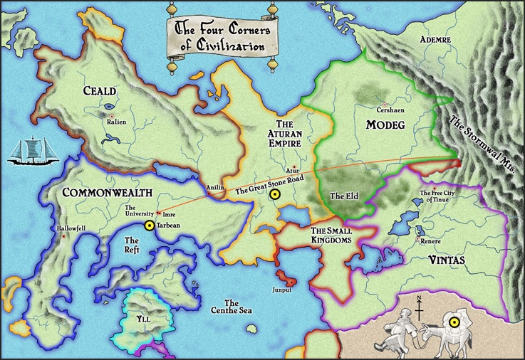
The Map Is Not The Territory
The map in the books is problematical to say the least. I first read NW as an ARC and it didn’t have a map, so when I bought the paperback I was delighted to have it until I discovered it was missing an awful lot of stuff I would want to have located. I’m also interested in why it’s called the Four Corners of Civilization, when there are more than four and also when there are references to four civilized virtues with concrete locations. Puzzling!
RoryB says:
Isn’t it curous that in a series that is so very exacting in the words it uses, that the map would be so “useless”? I strongly suspect that we’re missing something there.
CV12T suggests:
I strongly suspect the map’s vagueness is intentional. In the cliched fantasy map, you can look at the map at the beginning of the book and know that all the important places are marked and you’re probably going to visit most of them (I think there was a bit on this in Diana Wynne Jones’ Tough Guide to Fantasyland, but I don’t have a copy, unfortunately). This map is a subversion of that.
The map has all these details, it looks convincing and authoritative – but although it may be accurate, it omits so much that anyone who looks at that map and thinks they understand the world has been fooled. I have to wonder if the map is some sort of metaphor for the story as a whole.
Remember the scene in the Eld, where Marten talks about maps? “
“Maps don’t just have outside edges. They have inside edges. Holes. Folk like to pretend they know everything about the world. Rich folk especially. Maps are great for that.” (p. 560).
And AnotherAndrew says:
Regarding the uselessness of the map: I wonder if it might be a prop, like the map in The Hobbit, rather than a guide, like the maps in LOTR. Perhaps at some point the characters will discover this map, and puzzle over what it has and does not have on it.
Whether or not this is the case, the map is deeply unreliable, doesn’t have on it half the places one would want on it — not just Newarre, which may have plot reasons to omit, but Severen, which really is a major city, and the ruins of Myr Tariniel. Rothfuss must have a reason for giving us a pretty and useless map — but whether it’s subversion of tropes or a prop or just a desire to have us off balance, I can’t say.
The Middle of Newarre
Yes, it does sound like “nowhere.”
GBrell has located Newarre to my satisfaction:
An argument for why Newarre is in western Vintas (and associated corollaries):
The location of Kvothe’s hiding place Newarre is one of the ongoing questions in the series (Thanks a lot, stupid map!). Its location was discussed in some of the earliest threads with most people pointing out the obvious homonymic pun that Newarre is “Nowhere,” but the only real suggestion I saw given for its location was that Newarre is in the western Commonwealth.
I think this is wrong and I will elaborate why, instead, Newarre is most likely in western Vintas, probably on the southern border of the Eld.
The first piece of evidence we have is Kvothe/Kote’s admission that the Scrael come from the east and his surprise that they’ve “made it this far west yet.” He “thought the mountains –“ presumably would have stopped them or slowed them down.
Looking at the map, we see that the only significant mountain ranges that could have held them back are the Stormwal mountains in the far east and possibly the Eastern Cealdish range. Mountains in the Commonwealth are on the western shore (and Newarre is clearly not a port community) and none in Yll appear to run north-south.
C12VT in Thread 1 pointed out this suggests a far western location, but I think that’s a slight overreaction. More likely is the idea that he’s decently west of a mountain range (or that the mountain range is westerly), rather than on the other side of the continent.
This leaves us with three countries that border a sizable mountain range: Ceald, Modeg and Vintas.
We can rule out Ceald because a) no one appears to be speaking Siaru (unless they all are and Kvothe isn’t mentioning it) and b) “grown Cealdish men don’t give away money. . . . They don’t even buy things if they can help it” (NotW, 223). This isn’t behavior we’ve noticed in Newarre. Also, I haven’t noticed any descriptions of the “ruddy complexion and dark hair and eyes” that characterizes a full-blooded Ceald (NotW, 226).
Here are the arguments for why it’s Vintas:
The smith’s prentice states that the “king’s coin” is not “a silver noble” but “a whole gold royal” (WMF, 18). The soldiers who attack Kvothe learns of his apparent wealth by asking to break a gold coin, a “whole royal.” (WMF, 891). This is confirmed to be Vintish coin when Kvothe discusses having “two gold royals, four silver nobles …” after being dismissed by the Maer (WMF, 927). We know that “beer is three shims and a private room costs copper,” but that doesn’t provide us with much as “shim” appears to be used generically to mean a small amount of money (NotW, 44).
Chronicler carries a “whole silver talent … in a jar of ink,” but he travels extensively and, as he noted, it’s more a “luck piece” (NotW, 20-21).
Next, Bast has on his shelf “[r]ings of horn and leather and woven grass” (WMF, 985). Coincidentally, those are the exact three examples used by Bredon to describe how the common folk (presumably of Vintas) use rings. “A young lover might give a ring of new green grass to someone he was courting. A ring of leather promises service … A ring of horn shows enmity … Profound and lasting enmity” (WMF, 444). *Aside: Wonderful speculation as to who owes Bast service and who holds a vendetta against him.
Now why I believe Newarre is on the Southern edge of the Eld.
This is going to be accomplished by a curious triangulation.
First, Kvothe, when he first meets Chronicler at the Inn, asks him, “How is the road to Tinue?” We know this is an idiomatic expression (NotW, 273), but Chronicler reaction is confusion, followed by “I wasn’t heading to Tinue.” This implies that they are currently somewhere close enough to Tinue for that expression to be literally askable.
Second, when Kvothe fakes having a bum knee in the beginning of NotW, he mentions that he got the “wound” “on my way through the Eld three summers ago. … It’s what made me give up the good life on the road” (NotW, 29). Counterpoint: the farmer that gives Kvothe a ride to Tarbean mentions “this side of the Eld” as an idiomatic expression, so the giant forest is well known.
Third, when Abenthy is talking to Arliden and Netalia, he asks them what the village-folk are afraid of. In Vintas, they reply “Fae” and “Draugar,” neither of which we’ve seen mentioned by the villagers in Newarre. They are scared of demons, however, much like the people of Trebon. According to Arliden, people in Atur are scared in demons.
So we’re looking for somewhere that’s in Vintas, near Atur, Tinue and the Eld, which gives us a small jutting of land south of the Eld, bordering the Small Kingdoms, but quite close to the Aturan Empire. It also is fairly west of the Stormwal Mountains.
A counterpoint: When talking about the bleeders, Chronicler mentions that his father hates them as much as the common folk, which would imply that he’s Vintish. This is never really suggested, but never disproven. Also, note that while there is rampant speculation that Lochees is related to “Lack-keys” and “Loeclos,” they aren’t mentioned in Caduceus’ list of family splits.
A fun corollary that could be support: It’s fairly common to assume that Kvothe kills Ambrose, who has ascended to the throne of Vintas. If this is the cause of the current civil war with the Penitent King fighting rebels (NotW, 16), as Kvothe somewhat implies (“I’m responsible for everyone who dies in this stupid war” (WMF, 23)). This also explains why the common people would refer to him as Kingkiller (and why his ransom would “a thousand royals and a duchy [so Vintas has Dukes…]” (WMF, 20).
Taken together, I feel fairly certain that Newarre is in Vintas and has attempted to place its location.
I’m convinced.
Kurt Monmtandon has another piece of possible supporting evidence:
Kote and Bast are in Vintas, and that the Maer is now King. The soldiers that attack him in WMF are wearing blue and white, and refer to theirselves as “the king’s own.” Sapphire and ivory are the Alveron family’s colors.
Distances and Severen
GBRell asks about distances:
We don’t have a great handle on distances in this world. We have lots of anecdotal evidence, but no clear metric (nor the guarantee that the map is “to scale”). We can use a couple of these to try and guess at a distance. Riding constantly (Kvothe suggests using a post letter which would allow the rider to exchange tired horses for fresh ones), Kvothe says it would take three span to travel from the University to Severen overland. Severen is presumably on the Western coast of Vintas, since it’s a harbor city. This also makes sense considering it was supposed to take about a dozen days to reach it by sea (ultimately took sixteen, which Kvothe discusses as less than two span). *All from WMF, 365-67.
CV12T has a couple of specifics:
Kvothe tells Devi it is “A thousand miles with some to spare” from Imre to Severen (WMF, p. 360).
and
Another distance: Imre to Tarbean is 40 miles (WMF, p. 960). So from that we can derive an approximate scale for the map, assuming it is drawn to scale.
Thistlepong notices that Severen is on a river, not the sea:
We have the days/months/year:
single day/11 day span/4 span month/8 month year
1/11/44/3521000+/-100 miles in 28-33 days is more than reasonable, considering the time he made from Imre to Trebon.
Is Severen a harbor city? Kvothe speaks of traveling up the Arand River to Severen after passing Junpui. Presumably its dock is on that river? But the only river marked on the map leading from the Centhe Sea into Vintas runs right through the middle of the Small Kingdoms.
CV12T asks if the river is the border:
Maybe the Arand River forms the border between Vintas and the Small Kingdoms. We wouldn’t necessarily be able to tell there was a river there on the map with the border obscuring it.
GBrell agrees about the river:
I was confused because we know there are docks: “I spent the next several hours on the docks and found a ship leaving the next day for Junpui.” (WMF, 928)
But his description of the city does not include a harbor, I think I assumed it.
Note that Ambrose’s father rules the Pirate Isles (WMF, 938), which are “some miles to the south” of Severen (WMF, 368). But curiously not on the map (and nothing that could qualify as Isles either).
My best guess is that the Pirate Isles are off the map to the south and that Severen lies on the river that the Tinker leading the Pack Mule is pointing at with his foot. No idea why it’s so much darker than the other rivers. (Or it could be the other river just south of that).
Something something ’ell
We’ve talked a lot about Myr Tariniel, Selitos’s city and original home of the Amyr. Of course, we don’t know if the ruins exist in the real world or if they’re across the border in Fae.
C12VT:
It’s suggested that the Great Stone Road is very, very old – older than the Aturan Empire. On the map, the Road starts in Imre and ends in the Stormwal Mountains. I think Myr Tariniel is (or rather, was) at the end of that road.
The other end of the road is at Imre and the University, and Imre is also called (once, by Cob) Amary, and TyranAmiros proposed way back in the first spoiler thread that it might be Amyr-land by analogy with Adem-re. There are also the ruins of the Underthing to suggest that the University is even older than it looks, and it looks pretty old as it is. We’ve talked about it possibly being the one city that wasn’t destroyed, but I think that’s a lot more likely to be Tinue, see below.
AnotherAndrew wonders if they might be the twin cities:
Among the cities are the twin cities of Murilla and Murella. The University and Imre are twin cities. Are they built on the site of those two? We are told at one point that the University was founded among the ruins of an older university.
But Thistlepong discovers that the University is, or was, Belen:
I took MT to be at the Stormwal end of The Great Stone Road and Belen at the University end. The letter Denna sends is addressed to Belenay-Barren.
Tyran Amiros finds more evidence:
Both Kvothe’s letter to Ambrose at the end of WMF and his story about the Beggar and the Edema Ruh mention Belenay as well.
C12VT suggests:
Also, the poem Arliden recites about the greystones – he doesn’t remember the end, saying “Greystone leads to something-something-ell”. This may be far-fetched, but it occurred to me that “Myr Tariniel” would scan here.
There’s still lots of room for speculation.
The Road to Tinue
TyranAmiros suggested:
I wonder if Tinue was the city that survived (Tinusa—>Tinue). This would explain the idiom “How is the road to Tinue?” rather nicely: it would have been how the survivors of Lanre’s devistation of the seven cities asked if there was danger lying ahead as they fled to the one remaining city.
Tinue’s called the “Free City of Tinue” on the map, which could be more evidence. I’m going to believe this unless it’s contradicted later.
Jo Walton is a science fiction and fantasy writer. She’s published two poetry collections and nine novels, most recently Among Others, and if you liked this post you will like it. She reads a lot, and blogs about it here regularly. She comes from Wales but lives in Montreal where the food and books are more varied.


