Fantasy maps usually reside in a book’s endpapers, or in the front of the book. They’re part of a fantasy novel, but not necessarily a part of the narrative: they are, as Stefan Ekman has pointed out, part of the paratext (to use Gérard Genette’s term).
But every so often, one of these maps makes a break for it, escapes from the endpapers, and lands in the story itself, where it may find itself in the hands of the story’s protagonists.
What happens then?
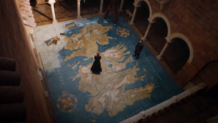
Because maps are a visual medium, let’s start by looking at a couple of visual examples. Peter Jackson’s 2002 film adaptation of The Two Towers adds a scene in which Faramir, hiding in Henneth Annûn, studies a map of Middle-earth. And in “Dragonstone,” the first episode of Game of Thrones’ seventh season, we find Cersei and Jaime Lannister scheming in a courtyard of the Red Keep where a still-incomplete map of Westeros is being painted on the floor.
In neither case is the maps’ presence incidental, nor their symbolism subtle: Faramir notes that Rohan and Gondor are surrounded by the forces of Saruman and Sauron; Cersei simultaneously reaches out to claim the entire continent (“It’s ours now; we just have to take it”) even while she and Jaime feel their enemies closing in around them. The maps mirror the dialogue, but more importantly they’re a visual aid for the audience: they help us situate the action.
These are far from the only instances of maps appearing in either series (or, in the case of “Dragonstone,” even in that episode: Cersei’s map is mirrored by the Dragonstone map room). But what’s interesting is that these two maps in particular are used directly by the characters, and they each make use of the default fantasy map style, which we explored in our last installment. (The maps are even lettered in an Uncial script, which has become pervasive in recent fantasy maps.)
Here’s the thing: I don’t think fantasy maps should turn up inside their own stories. For reasons I will set out in this essay, fantasy maps don’t belong in the hands of fantasy characters. And if you’re building a fantasy world that has maps in it, there are several things you need to take into consideration.
Who Are Fantasy Maps For?
The main problem is that fantasy maps are for readers, not for characters.
Let’s return to Stefan Ekman’s 2013 monograph, Here Be Dragons: Exploring Fantasy Maps and Settings, which gave us our working definition of the default fantasy map style: “a pseudomedieval aesthetic” in which “pre-Enlightenment mapping conventions” are added to a “mostly modern” map (p. 66). Note the words pseudomedieval and mostly modern. A fantasy map is a modern artifact, but with enough pre-modern flourishes to give it a semblance of ancientry. That’s not an accident. A fantasy map can’t be purely medieval in aesthetic, eschewing all modern map elements, because it would be unintelligible: for example, Ekman points out, “the serrated bands and cockscombs that represented mountains on many pre-Renaissance maps cannot be deciphered by today’s readers” (p. 41).
The reverse is also true: a pseudomedieval, mostly modern fantasy map would be, to the denizens of the fantasy world being mapped, a thoroughly alien artifact. It’s not simply that they would fail to understand such a map (more on that momentarily). They would fail to understand the need for it.
Maps are tools. Each map has a purpose: you wouldn’t consult a nautical chart or a cadastral map to figure out the best way to drive to Poughkeepsie. A fantasy map has a purpose as well: to ground the audience in an unfamiliar world. It’s not for nothing that the fantasy novels that come with maps tend to be secondary world epic fantasies: their immersive detail desperately requires a map to keep track of where everything is happening. A map is part of the fun, along with the coats of arms, dramatis personae, family trees, languages, and other marginalia—the paratexts—that frequently accompany an invented world.
A reader who’s lost track of where things are happening may stop and flip back to the front of the books to check the map (incidentally, a much harder thing to do with ebooks). Faramir and Cersei are doing the visual equivalent in their scenes. Not for nothing do Faramir and Cersei walk through the relevant geography (in Cersei’s case literally). These scenes are the geographical equivalent of “as you know, Bob”: they know full well where everything is located; it’s the viewer who might need reminding. Here is the stage on which we set our play.
But in-universe, a map like Faramir’s would not be worth carrying around. Like most fantasy maps, it’s not particularly information-dense: mostly empty space, designed to be legible on the big screen (or the small page). A denizen of Middle-earth, or any other secondary world, would not use such a map. They would not understand such a map. And for the most part they would not need such a map, because the fantasy map’s specific purpose—to ground the reader in the secondary world—is superfluous to someone living in that world.
Inside a fantasy world, a fantasy map is basically useless.
Maps and the Medieval Mind
Which is not to say that the denizens of a fantasy world wouldn’t use maps. But those maps would look different, and they would be used for different purposes.
Fantasy maps—which, again, are mostly modern—don’t much look like premodern maps: I wouldn’t be the first person to point that out. But the differences in style and appearance reflect differences in modes of thought. Premodern people, very few of whom travelled any significant distance, had different conceptions of space and time, and their maps were a reflection of that. As the French historian Patrick Gautier Dalché argues, medieval maps could have both a spiritual and a functional purpose: whether it was a mappa mundi hanging in a cathedral or a map of the Holy Land, a map could situate its observer in both sacramental and corporeal worlds, and aid in prayer as much as it could in travel. And while portolan charts might lack the mathematical rigor of later cartography, traders and navigators still relied on the charts’ networks of windrose lines to keep them on course.
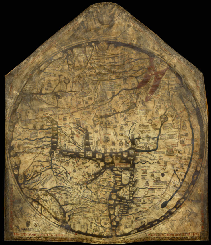
Mappae mundi are a case in point. They were never meant to be accurate; they were schematic, diagrammatic repositories of knowledge encased in a map-shaped object—strictly speaking, in the form of a T-O map, which divides the known world into three rather abstract continents, with Asia (and east) usually at the top of the map and Jerusalem at its centre. The 13th-century Hereford Mappa Mundi, for example, included text and visual information that were not strictly cartographic: not just geographical locations, but scenes from the Bible and from classical mythology.
It’s more of a diagram than a geographical map—something you’d never expect to be geographically accurate. Sort of like the Tube map depicting the lines of the London Underground, if the Tube map also happened to be encoded with a library’s worth of additional detail. Also, using the Hereford Mappa Mundi as a map in the modern sense, to find your way around, would be magnificently beside the point, as comedians Jay Foreman and Mark Cooper-Jones make clear in an episode of their Map Men web series:
A single map from medieval Europe can’t be representative of all of premodern mapmaking, but it can serve as a useful example for the point being made here: that it’s a mistake to think that premodern people used maps in the same way as we do.
It’s reasonable to assume the same for denizens of a premodern fantasy world.
Fantasy vs. History
But hold on a minute, you might be saying. That’s history; we’re talking about fantasy. Historical accuracy in fantasy isn’t an absolute requirement: history, after all, doesn’t have wizards or dragons. Why should it be any different with maps?
That’s a fair point, and one that has come up whenever someone advocates a more realistic, historically informed approach to fantasy worldbuilding.
In this case, I’d say it depends on what kind of fantasy world we’re talking about.
If the fantasy world in question is a self-aware Fantasyland that knows full well what it is, one that plays with tropes in a self-aware, satirical or metafictional fashion, if it’s more like Derkholm, Fillory or Landover than it is Middle-earth or Westeros—if it’s in on the joke—then by all means have the locals use the default fantasy map style. It may even be essential that they do so. In such fantasy worlds anthropomorphic maps have even acted as characters: see, for example, Mr. Map in Catherynne Valente’s Girl Who Circumnavigated Fairyland in a Ship of Her Own Making.
If, on the other hand, your fantasy world has aspirations to realism—if you’re concerned about diseases and crops, trade routes and weather patterns, legal codes and currency systems—then your characters’ maps should probably eschew the default fantasy map style and adopt something more realistic.
That’s not to say that the maps of a fantasy world should resemble real-world premodern maps. “Realistic” does not automatically mean “real-world.” Depending on how that world has been built, a mappa mundi or portolan chart might well be just as out of place as a fantasy map.
But it is to say that maps are a product of civilization. They do not exist in isolation. For your adventurer to have a map in their hands, a number of things have to be in place first. The existence of that map raises questions: it implies the presence of bodies of knowledge, technologies and even entire industries. Answering these questions can make a fantasy world richer and more interesting.
What Maps Tell Us About a Society, and Vice Versa
Let’s start with the physical map itself: the paper the map is drawn or printed on. How is that paper made? What is it made of? How expensive is it? Who produces it? If it’s papyrus, amate or some form of wood pulp paper, it’s relatively inexpensive but delicate; if it’s vellum, it’s durable but rare and expensive; if it’s linen-based paper, it’s somewhere in the middle: cheaper than vellum but not as cheap or as plentiful as modern (19th-century and onward) wood-pulp paper.
Next, is the map drawn or printed? If it’s printed, that presupposes the existence of printing presses, and everything required to make printing presses. If the map is drawn, then it’s a scarce and valuable artifact, one to be treated with great care. Copies would have to be made by hand, either as needed in the field or by scribes—are there scribes or copyists in this world? Is there a master copy of the map? Is it the only copy? Where is it kept: in a library; in a monastery? Where are the repositories of knowledge in this world?
Buy the Book

Fate of the Fallen
And how was that knowledge acquired? In order for a map to be drawn, the mapmaker needs to know what goes where. A map is the end result of countless measurements in the field. How is surveying done in this world? Precise surveying involves some fairly involved mathematics and equipment, neither of which may be available to a premodern society. Pacing out distances and astronomical observations can involve significant margins of error (and forget about using astronomical observations if your fantasy world is a flat earth).
Maybe the fantasy world’s mapmakers could recruit talking eagles to do their surveying for them. Maybe the fantasy world’s mapmakers are eagles. (What a story detail that might make.) Barring such supernatural help (which in fantasy cannot be ruled out), premodern maps will by and large not be very accurate. Which could also make for an interesting and surprising story detail, especially since modern audiences tend to assume that maps are accurate.
We also tend to assume that maps are unbiased—that they will not lie to us. If it’s on the map, it must be there. Is that the case? Does this fantasy world’s maps have the equivalent of trap streets? Could false maps be distributed by the enemy as part of a disinformation campaign?
Which brings me to the next question: how well-known was the information on maps? Is that information a secret, as it was during the Age of Discovery, when maps could be state secrets and unauthorized possession could get you executed? A top-secret military facility, a newly discovered territory: information like that can can be valuable, even strategic—far too valuable to fall into the wrong hands.
So it’s worth asking: who would own a map? Who would have reason to have a map in their possession? And beyond that, who would even be able to read a map? Even today, map literacy is not a given (in 2016 Britain’s Ordnance Survey even launched a campaign to teach map reading skills). But reading maps isn’t necessarily a transferable skill: not all maps use the same symbols or speak the same visual language. The ability to read a navigational chart would largely be limited to ship’s captains and navigators, and would not necessarily be transferable to the maps used by an overland caravan, or to battlefield maps. They might not even follow a common set of design principles; every map could use the private language of its mapmaker.
Anything is possible.
I imagine that in a premodern world, where paper is rare and knowledge is limited, the idea of a general purpose map, one that could be apprehended by the general (educated, privileged) public, would not necessarily occur to anyone: the infrastructure for such a map would not yet exist. What maps that did exist in such a world would essentially be technical documents created for a specific purpose: religious, military, trade, navigation. They would be specialists’ tools requiring specialists’ skills to parse and decipher. A ship’s captain would have a certain kind of map, a spy would have another, a priest still another.
And each of those maps would encode so much information about the society that produced it. To have a map without considering how and why it was made, and by whom, would be a missed worldbuilding opportunity.
Even so, it’s one thing to imagine how different a fantasy world’s map would be, or the economics and technology behind its production. But if it doesn’t appear on the endpapers, would such a map ever be seen by readers? And if it appeared there, would we, as readers in the real world, be able to understand it?
Jonathan Crowe blogs about maps at The Map Room. His nonfiction has appeared in AE, The New York Review of Science Fiction, the Ottawa Citizen and here at Tor.com. His sf fanzine, Ecdysis, was a two-time Aurora Award finalist. He lives in Shawville, Quebec, with his wife, their three cats, and an uncomfortable number of snakes. He’s on Twitter at @mcwetboy.


